I stuck my arm out and latched onto a tree to prevent myself from careening down the trail. I caught it just in time as my body kept moving but the tree, thankfully, pulled me back like a puppet on a string. I’d been warned that this trail would be ridiculously difficult but it fell on deaf ears. In fact, it only made me want to do it more.
Standing there, I thought, “They were right but I don’t want to admit it,” while simultaneously wishing to myself that curling into a ball on the floor, melting into a puddle and dripping down the rest of the trail was an option. I was in the middle of a 3-hour descent that was almost vertical, on slippery dirt, and without anything to hold onto. One false move would mean a serious injury. I’d never experienced anything like it before.
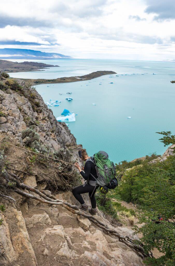
Yet I knew that going back up would be worse than continuing on. Then I’d just have to do the same thing in the other direction, going back over the pass and to the 2-hour trail that was so narrow, one wrong step would mean falling all the way down to the Southern Patagonian Ice Field. There would be no walking out of that scenario. I really didn’t want to repeat it.
I had no choice, so I just kept going. I started wondering to myself why I was there. Was this actually even fun?
Then the bushes cleared and I could see a glimmering lake with ice bergs floating in it. Nobody around for days, it was ours – Steve who had hiked the Huemul circuit before, a young German guy named Joachim whom we met along the trail, and me. That view made me remember why I took on the challenge in the first place.
That was on day three of one of the most difficult hikes I’ve done and yet somehow it’s (mostly) fond in my memories.
It started out with some information Steve, who trekked the Huemul Circuit three years ago (I could NOT understand his motivation for doing it twice), hadn’t bargained for.
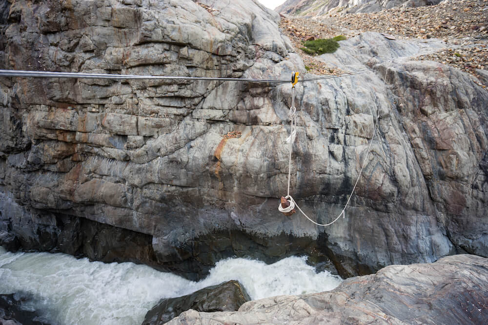
“If you’re going to want to do this trek, you need a harness and carabiner to rappel across the rivers.”
Steve had just forded the river last time. Yes, he had forded the freezing river that was coming down from a glacier. And then just hiked in freezing wet pants afterwards. I liked the idea of the harness much better. We had to rent these in town and carry them to duration of the trek (and so will you).
You see, when Steve had been there previously, the metal wire with the pulley was broken. By the time we arrived it had been fixed again. I have no idea how often this thing breaks and certainly didn’t let myself contemplate it too much while actually on it.
Why in the world did we want to do this? We’d gone from rural areas without many, if any, other western tourists on the Carretera Austral to the much more popular and crowded El Chaltén and we wanted solitude again.
This circuit is difficult and technical enough to keep most people away, and it’s one of the only trails in Patagonia that you can see the Southern Patagonian Ice Field from. It’s also possible to get sunrise at the glacial lagoon all to yourself. Seriously, with nobody else there.
The challenges: Most of the trail is not marked (download the Argentina map on the maps.me app before you go to help with navigating), three hours of the trail is almost straight down, and you must carry absolutely everything you will need on the trek, and I mean everything, including a carabiner and harness that you can rent from shops in town. The only thing you don’t need to bring is water.
Day One
Day one was rather pleasant. We left in the late morning and took it easy, checking in with the ranger office, registering (they’ll send out search and rescue if you go missing), and heading out on our way.
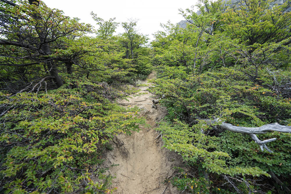
It was an easy hike from the town of El Chaltén through a bit of forest and a bit of open areas. There were sweeping mountain views and a casual glacier here, there, and everywhere.
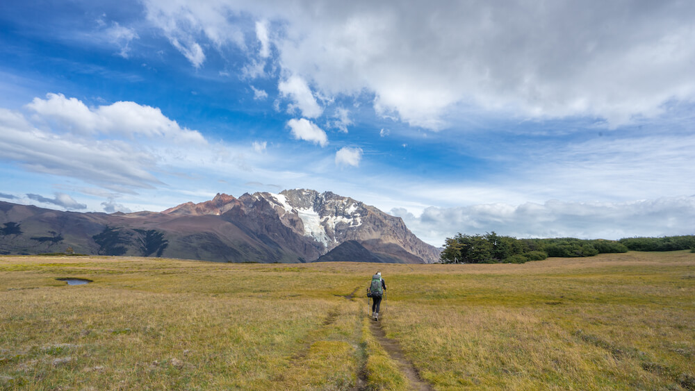
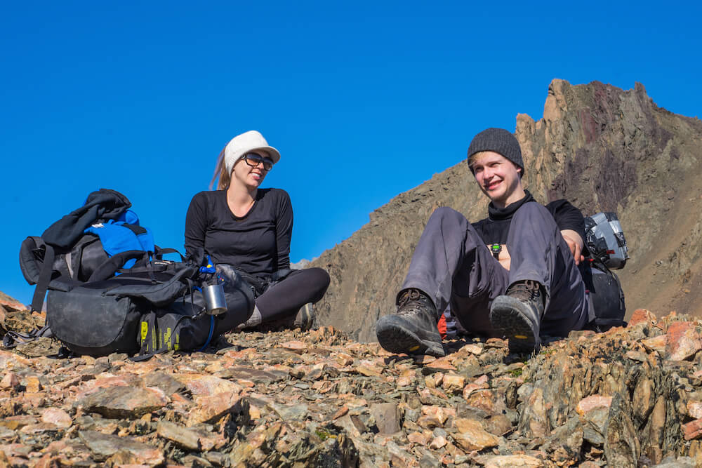
At the end of that day it was seeming pretty easy. There were about 6 other tents all around and we cooked some pasta. Steve somehow managed to find it funny rather than annoying when I knocked down the boiled water twice trying to turn off the flame.
Day Two
For most day two, there’s no trail. The second day involves strapping on a harness first thing in the morning and pulling yourself across the wire rope. It’s much easier without a backpack on so send that across first to your hiking buddy.
The next few hours will be spent climbing over a rocky glacier moraine, then climbing hand and foot up a gravel trail for 1000 meters.
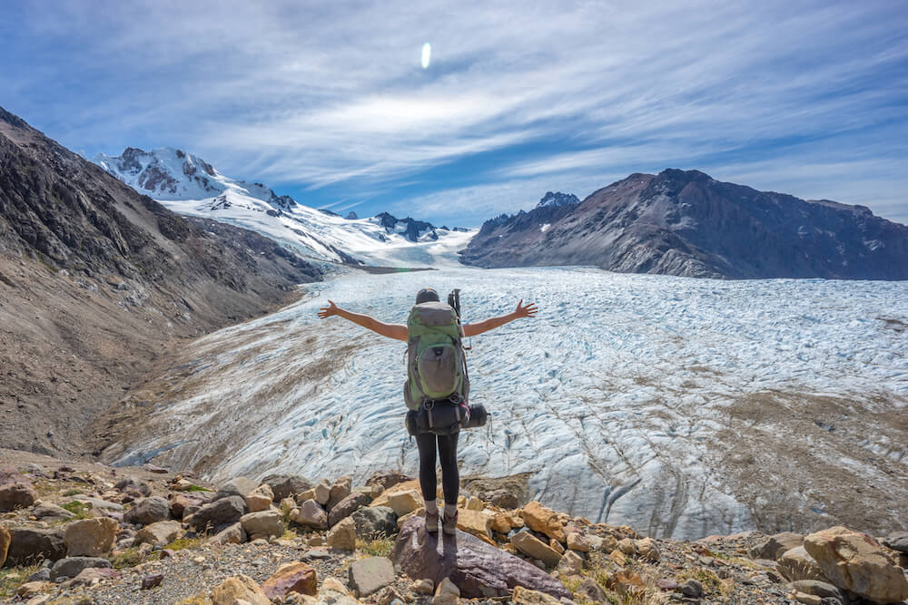
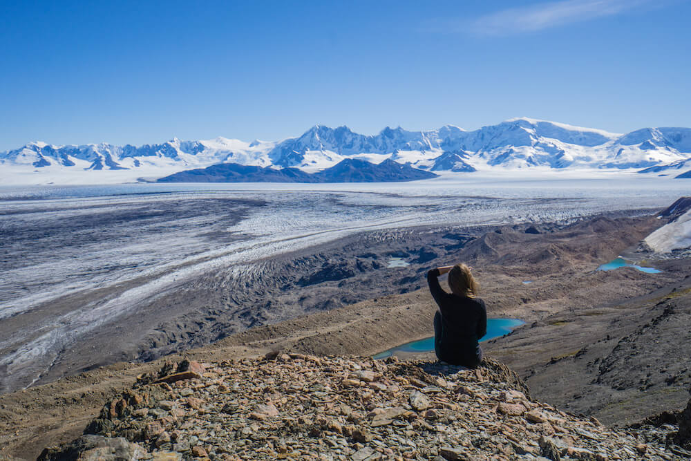
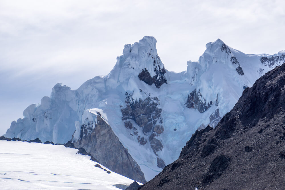
It will be a challenge for sure. This is easily one of the steepest trails I’ve done, and I was VERY glad to have had walking sticks with that steepness. Thankfully the view is amazing during this part of the trail. To your right there will be two big glaciers and at the top, you’ll have the view of the Ice Field at the Paso Viento.
The Paso Viento is so-named for normally being ridiculously windy. In Patagonia, when something is characterized as ‘windy’ it does not mean a stiff breeze, it means wind pelting you so hard that it picks you right up off your feet and slams you into a rock if it wants to.
That day, however, there was no wind whatsoever. It was a clear day and we could see straight onto the ice field and beyond.
In that moment I was staring at a part of planet Earth that is still very much uncharted territory. Maybe I’m not the one out exploring and mapping it out, but I sure was content in that moment to be the only girl sitting there looking at it.
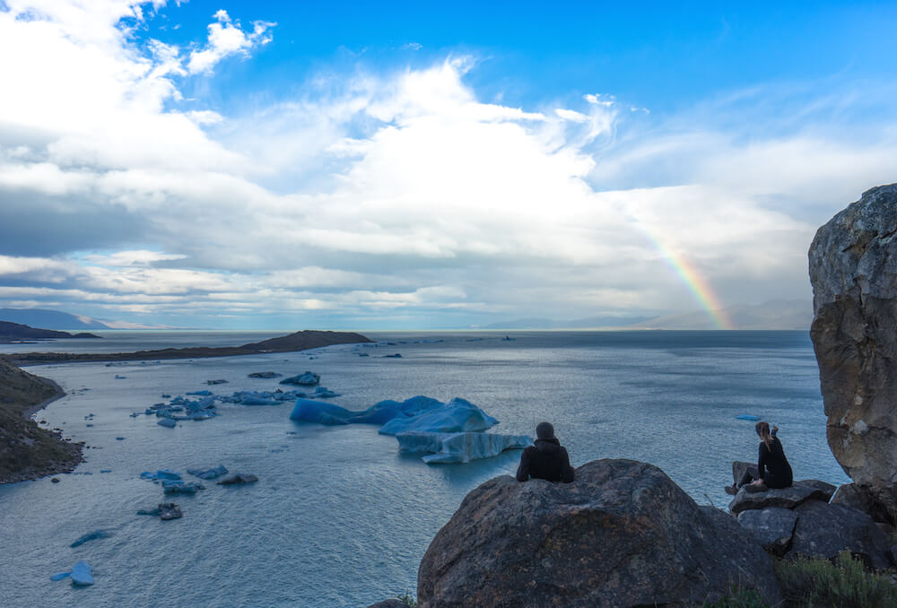
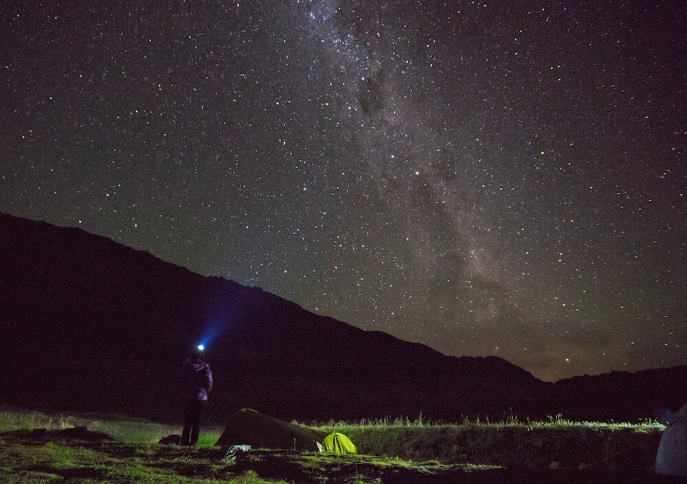
That night after a steep descent down, we slept under some incredible stars next to the Southern Patagonian Ice Field. A group of five others showed up as well, but that was it. Otherwise, we were the only humans out there for days.
Day Three
Day three was the long and very tough one that I mentioned in the intro of this post.
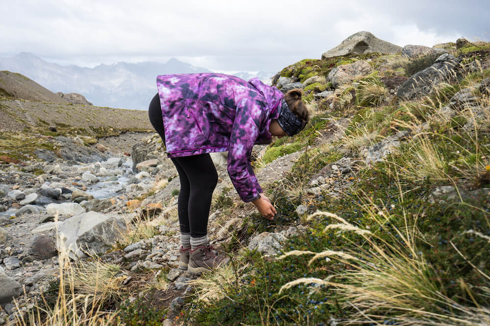
The beginning was more or less fine. We woke up with the sun and packed up quickly, aware that it was a long day until we got to the glacier lagoon. We picked a few Calafate berries along the way and readied for the tough part.
The trail narrowed to the point that one false step would mean falling down all the way to the ice field. I was very aware that wasn’t something anyone would be walking out of.
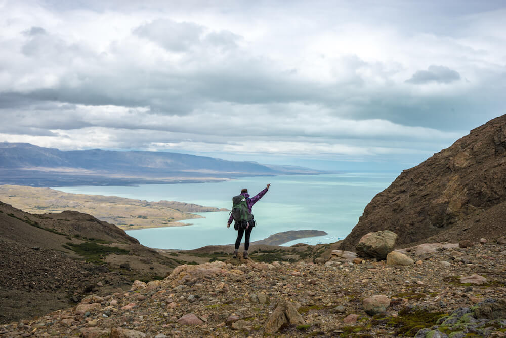
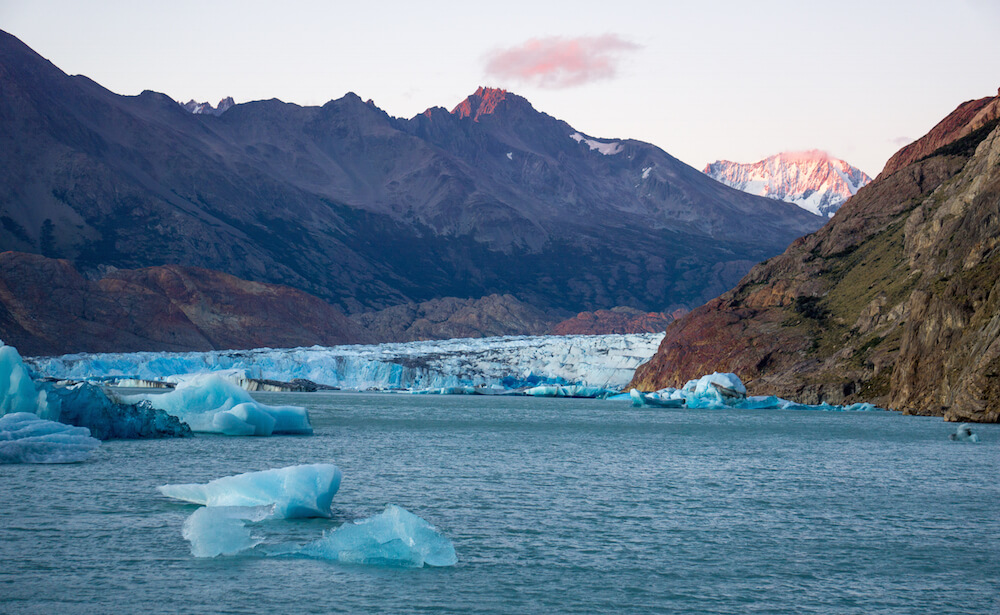
Then we had another pass to climb up and over -the Huemul Pass. The wind picked up but it was in my favor and started to actually push me up the trail, much to my gratitude. Once I reached the top, I could finally see the glacial lake. Like much of the water in Patagonia, the minerals made it an intense aquamarine, coupled by the crystal clear water from the glacier.
I’ve already waxed poetic on the descent thereafter earlier in the post, but suffice to say, it was steeper than anything I’ve ever tried and to add insult to injury, the plants poked and scratched me the whole way down.
Patagonia ain’t for pansies.
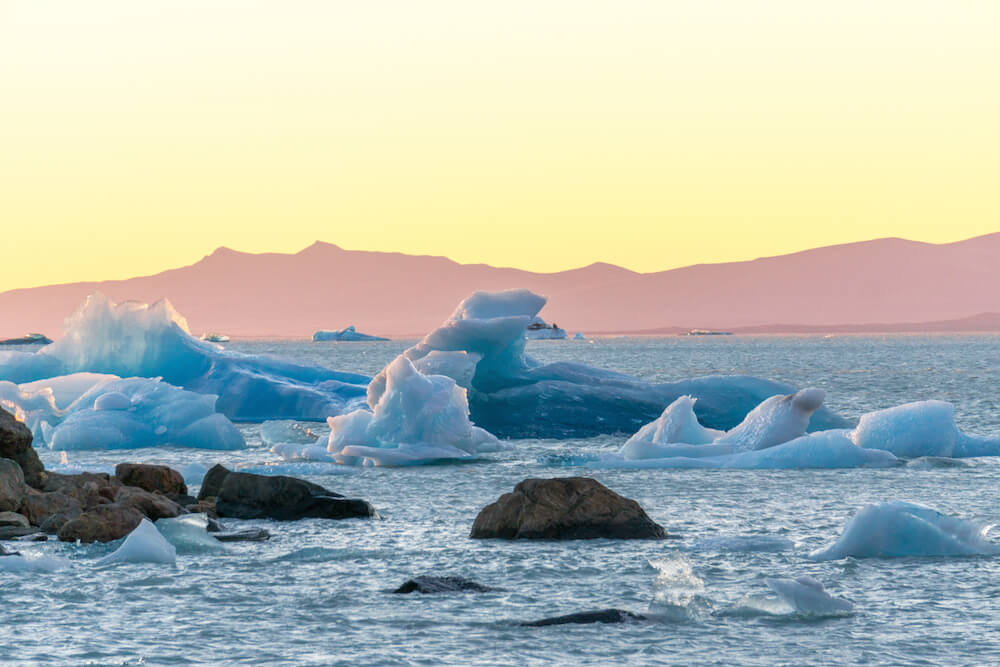
That night we settled into a campground right on the water as the rain started to fall and the wind picked up. We found a tree to hide behind for cooking and finally tucked into the small bottle of whiskey we’d brought along, taking chunks of the ice out of the water because wouldn’t you want some 10,000-year-old glacial ice in your beverage? In the morning, we’d see the sunrise reflect on the ice bergs floating in the water and it would be glorious.
Day Four
The morning was peaceful and so many shades of gold and red, and unlike my experience in Iceland where there were a good 25-40 people, we were the only ones to see it. Seriously, we were the only people there!
The hike out from there was more like the first day’s – it wasn’t too challenging, though it was long at 18km and by the time we reached the end, pulling ourselves across another pulley again, we were absolutely exhausted.
The thing is, at this point you have to try to find a bus. The busses coincide with incoming tourist boats that visit the glacier in the late morning and afternoon. Hitchhiking is also an option, which is what we did.
An American tourist who had summited Everest twice gave us a lift, congratulating us for completing such a tough circuit. It paled in comparison to what he’d done, of course, but I still felt happy to have taken on this challenge and dominated it, even though at times I didn’t think I could.

Patagonia, you’re always unexpected, always tough, and always gorgeous.
Box Canyon Mark says
Absolutely blown away by your photos and adventurous spirit!
Kristin says
Thanks so much Mark!
Emma says
This is one of the most incredible things I have ever seen… I need to go and complete it! It is exactly the crazy kind of thing I like to do when travelling. Beautiful photos.
Karo says
What an adventure! Love all of it!
Rika | Cubicle Throwdown says
Absolutely stunning scenery, but that hike looks really tough! I’m content to sit back and look at your photos 🙂
Kassie says
These photos are amazing ? Not sure I would brave that hike but it definitely seems like it was worth it!
Ijana says
Hey, I haven’t read your blog in awhile cause a trip got me out of the habit, but what a great post to come back to! I’m a sucker for everything to do with hiking, and this is going on my list of hikes I absolutely must complete one day. The challenge is what makes it so rewarding, not to mention the beautiful views and the nature and the solitude 😀
Kristin says
Welcome back! totally agree that the challenge sometimes is what attracts me in the first place.
Paul Taylor says
Hey Kristin, you are really a good writer. I am glad to find your website and this post was amazing. I am bookmarking your site now so i will not miss your posts in future.
Cheers!
Brianna says
Damn girl. I was holding my breath as I did this trek along with you through your writing. You’re a beast.
Simone says
Wow, it sounds incredible! But definitely not for the light hearted 🙂 I know from experience that photos are hard to compare to the real thing especially when it comes to showing a gradient but that hill photo genuinely looks intimidating!
Kristin says
Nope anyone who hates heights or isn’t all that into hiking would have hated this hike! I almost hated it myself but oh man that view and the lack of crowds really made it cool.
Austin says
Really wanting to do this hike, what month did yal do the hike? And did yal hike it clockwise or counter clockwise?
Kristin says
Started from town and went clockwise. I cannot imagine, really, doing it counterclockwise.
John says
Hi Kristin,
Enjoyed reading your report of the the Huemul Circuit trekking, where I am planning to do next month.
I do have a question about the hiking direction.
From the map, if one started hiking from town, I think one must be doing counterclockwise. Am I missing something?
Kristin says
You want to head for the Paso del Viento right after you register at the ranger station. They can help further clarify for you, but there’s no way I can imagine going uphill on what would normally be the 3rd day. The downhill was scary but uphill would be almost impossible…it’s a super steep decline/incline
Carlos says
Hi Kristin!
Thanks a lot for this post. It provides some very good info about this circuit, which I’ve wanted to do ever since I saw it on Steve’s blog.
I have a couple of questions that perhaps you can help me answering.
1) How difficult it is to find the path in the unmarked sections? I’ve downloaded a GPX file from http://www.wikiexplora.com/index.php/Circuito_Cerro_Huemul, and I’ve installed it into a Garmin GPSMAP 64s, and I plan to buy a paper map in El Chaltén as well.
2) Did you have to ford any rivers, or were you able to use harnesses for all of them?
3) How cold were the nights inside your tent and sleeping bag? What kind of clothing did you wear to keep you warm while sleeping?
4) Perhaps this is the most important one. We’re not the fittest trekkers. We do hike regularly (I do 5km, 150m elevation gain and loss as training about 3 times per week, for example), but that doesn’t mean we’re thin. We’re obviously in better shape and have better training than most people, but you seem to be quite fit. Do you think we would have a horrible time on this circuit? I can deal with being tired, exhausted and wishing the climb to be over, but I think that I can deal with a 900m elevation gain, although I might be slow.
Thanks a lot!
Kristin says
1) Sometimes you won’t be able to see the path at all, that’s why I think having an offline map with plotted points on it with a GPS is important if not essential. Always look for the rock stacks to lead your way as well
2) We just had to cross two and used the harness for both
3) It’s more important to have a good sleeping bag than clothing for sleeping. More layers of clothing actually make the bag less effective. Go for one with a comfort level below 0 for sure. You’re sleeping next to the ice field!
4) I can’t say it’s not hard, but it’s not about being thin, it’s about being able to take on the challenge and having knees that can handle that intense downhill part. I feel like uphill is mental, downhill is knees.
cath says
What an amazing adventure. I think a bit too challengin for our family. I am wondering about doing only the last day back and forth. Would love to knoew what you think of that?
Kristin says
That would also be beautiful! You could see the glacier lagoon. Budget all day for it since it’s out and back.
Aura says
Hello, this seem exactly what I am looking for. I ve been looking for a challenging trek for ages. What other similar treks do you recommend anywhere in the world? I ve done gr20 and that was awesome.
Kristin says
Wrangell St. Elias in Alaska has some great backcountry options. Crossing glaciers, lots of steep moraine, though. hard on the knees!
Alfy says
Hey, great post! Do you think Huemul circuit is possible alone?
Kristin says
I met someone on the trail who asked if he could join us and of course we said yes. He’d done the first day solo but that’s an easy day. Hiking alone is never a good idea, especially considering day two is over a glacier moraine and it would be pretty easy to fall and never get found. I’d stay in a social hostel and try to find some people to join. It’s a tricky trail and much of it isn’t even visible, requiring a GPS and a harness to get across two rivers. It’s of course possible to do alone but not very smart.
John Sullivan says
I ended up doing this trail because of this blog post! Thank you so much for posting about it Kristin! It was freaking the most difficult thing I’ve ever done in my life haha. Was actually my first time doing a multi-day trek; I had the physical fitness but at times during the hike I was asking what have I gotten myself into and why did I have to discover your blog post =P, but no, the hike was just phenomenal. I was lucky to do it with someone more experienced (and doing the hike certainly made me slightly more experienced). Honestly seeing your picture of the Southern Patagonian Ice Fields sold me, and it was the most humbling thing of nature I have ever seen in my life. I actually met a few other people while backpacking last month who had also found out about and ended up doing this this trail because of this particular post. And then I ended up telling 3 more people about it who ended up doing it. The domino effect of one blog post is quite interesting. Hopefully many people who are able to do the trek find out about it; APN doesn’t seem to advertise it so much given how much can go wrong with the weather, but otherwise it’s an amazing trek. Thanks for posting about it and sharing your experiences!
Kristin says
Whoa, this was your first multi-day trek? Way to start with a bang! That’s the reason to go – that view of the Southern Patagonian Ice field. It’s just mind blowing.
I can understand why they don’t advertise the trek much. I can imagine search and rescue could have their hands full if they don’t make the trail clearer and especially that downhill and the glacier moraine. What an experience, though!
John Sullivan says
Agreed, the ice field view is just mind-blowing (literally, with all the wind we had up at Paso del VIento, though seems like you had little). But even the other parts of the hike are beautiful, especially considering it’s so seldom traveled. I did Torres del Paine about a week later solo and honestly wasn’t phased by it after doing the Huemul even though it was only my 2nd ever multi-day trek–a good way to be thrown into the fire.
Yea, apparently that downhill section has you go down vertically 500m over 1.2km horizontally, or about 42% decline. Even with hiking poles it’s ridiculously difficult. And yeaaaa we heard of a guy who got his foot stuck in one part of the glacier, but at least he was with friends and they were able to take him back. Then we met some freak-of-nature Swiss guy who left Chalten at 7 AM and made it to Refugio Paso del Viento by 4 PM without even registering to do the hike. Definitely a memorable hike!
Ashton says
Kristin,
Thank you for posting in such candid detail about your hikes. Your travels are inspiring to female travelers like myself. What time of the year did you hike the Huemul Circuit, if you don’t mind me asking?
Kristin says
This was in March. I think it’s probably only doable without snow 🙂
Mike says
Hi Kristin,
This sounds like a pretty tough hike. Do you think it could be done in 3 or even 2 days?
Mike
Kristin says
Not in 2 days unless you’re the type who can do an ironman without breaking a sweat. I guess three would be doable but I’d personally be miserable trying to do it that way.
John says
Hi Mike, it can definitely be done in 3 days, which would be a challenge. Two days is also very much feasible, but you would be hurting by the end. The record for doing it is 17 hours but two people from the UK (The Tempest Two) who seem like they’re very fit and trained a lot before doing it.
If you were to do it in 2 days, you’d leave from El Chalten and go all the way to Paso del Viento in one day before going to the hut. It’ll be a long day. The next day you’d go from the Paso del Viento Hut back to El Chalten. This would be at least 36km/22 miles. I did this one year ago and it was extremely challenging. If you really want to do it quickly, I’d recommend 3 days: go from El Chalten to Paso del VIento in one day, and then do after that do the hike as per usual. You can look at the video here where the people do the same thing:
https://www.youtube.com/watch?v=HAqpFR2KL8A
Alex says
Hi Kristin,
Your blog really has reached a lot of people. I am planning on doing the Huemul circuit as a result of reading your blog! I am wondering if you can give some extra pointers for people that might be interested in doing this trek: Do people need to bring a harness/carabiner, or will they be available in order to cross the river? Are there designated camping grounds to stay at? Where did you camp while you were doing this circuit?
Kristin says
Hi Alex, Thanks for asking, I thought I’d mentioned that in the post but I just re-read and I hadn’t! (added now) you have to bring your own harness and carabiner, which you can rent in town. There are designated areas to camp but there are not any facilities. You’ll see spots marked by rocks where you can pitch a tent as you progress. Hope that helps!
Margaret says
Hey Kristin!
Your blog is awesome and super helpful! My boyfriend and I are doing the Huemel Circuit, as well as the Circuit Torre and Fitz Roy. Do you know if we need to book camp sites ahead of time and what websites we would use?
Thanks in advance!
Kristin says
Depends on when you’re going for Torres del Paine. In high season yes, and I believe you’d need to do that with the owners of the various campsites – Fantastico Sur and Vertice Patagonia – online ahead of time. The free ones you’d book with CONAF. For the Huemul Circuit there aren’t really maintained sites. They are just piles of rocks and sometimes little sheds that you’ll see along the way. And Fitz Roy can be done in a day from El Chalten so no need to spend the night unless you want to, and I think for that you can just show up.
Leah says
Kristin,
Thank you for posting this guide! It’s hard to find many details online. I just completed the O Circuit in Torres Del Paine and I’m hoping to start this one on Tuesday with some friends I made on the O. I’m definitely a little worried about that descent and the river crossings, but hopefully it will all be ok 🙂
Kristin says
It’s so beautiful. You’ll really feel like you’ve earned it!
Sarah says
Hi Kristin, Thanks for all of the information. Your info on Argentina/Chile including this trek is incredibly helpful. We are debating hiring a guide for the Huemul Circuit, only if for the navigation assistance & help with the zip-line type river crossings. That being said, guided trips are quite expensive & we are normally pretty independent with our trips so debating going without the guide. I’ve read in other places that navigation is not too difficult with the use of a good map & experience w/navigation. I’ve also seen that it is possible to ford the first river crossing as long as the water levels are low instead of using the zip line system. We are experienced hikers, but the river crossings looked a bit intimidating to me! Is it easy to understand the harness/carabiner system across the river & did you feel safe with the crossing? Also, where did you end up renting this equipment? Thank you.
Kristin says
So even if you ford the first river, you’ll need to pull yourself across the second one. Plus, you’ll be freezing and soaked in glacial water up to your waist. It was easy enough for us to figure out how to use it and you can just go into the shops around town that sell and rent equipment and see who has them. We had to visit a couple to find someone who had harnesses.
It’s definitely possible to lose the route as you go. The best thing you can do is bring a waterproof map and also plot the route out ahead of time on maps.me and track via GPS. Or, if you want to bring a guide, you won’t have to worry about any of those things. I felt fine without one. Hope that helps!
Myles says
To see the Southern Ice Field do you have to take the paths that take you across the rivers (with harnesses)? I’m doing a trip in winter there (late June to be exact) and I would like to be able to see the Ice Field but know that specific trail isnt an option that time of year.
Any advice on what to do for winter? We’re looking at Cerro Torre and Fitz Roy/Laguna de los tres.
Thanks!
Kristin says
Yes you do have to cross the rivers with harnesses. However even in April of this year I heard that the path was already completely snowed in and impassable. Same might be true of Cerro Torre and Fitz Roy. You’ll have to see how the snowfall has been when you arrive I’m afraid.
Karen says
Hello!
We are planning on doing the Huemel circuit just after Christmas this year and I’m very glad I came across this post. I have a question, how did you manage the steep descent? It looks like in one of your photos you are holding onto some rope? IS that for the very steep descent you mention? If not how did you get down it? I’m very pleased you posted what you saw on your trip as now I know what we’ll see and am very pleased we are doing this trek!
Kristin says
That rope is only present on that one part. Otherwise, there’s no real tactic other than using hiking poles. The descent was really hard for me and I genuinely did not enjoy it. It took about 3 hours of straight downward hiking on loose dirt. I think this is why most people don’t attempt this hike and there are so few others on the trail, though!
David Reynolds says
Hello Kristen,
Myself and two other guys are doing the Huemul in early October. What time of year have you done this hike? Any tips for October weather down there? Also, just curious, but what was your pack weight starting out? And did you all have crampons going across the glacier? If so, what kind did you have? And is there a way to not go across the glacier with the potential of falling through?
Thanks! Great photos and story!
Kristin says
Hey David, there is no glacier crossing, so you don’t need crampons but you do need a harness. I went in March. I’m not sure about October as there might still be snow. It depends on the year I’m sure.
Val says
Hey David, when in October are you going? I might be Keen.
Ender says
By any chance do you have gps route tracks that I can download on the google maps. Thnks.
Kristin says
I don’t anymore, but we tracked on maps.me
bibo says
did it last year : fucking hard!!!this wind —
at the end its rewarding but FUCKING HARD!
Kristin says
LOL agreed
Mico says
I really liked reading your post. It seems like an excellent adventure. I am planning to do the circuit in December 2019 (9.12-12.12). I hope I find some fellow hikers for the trail, or if somebody reading this would like to join me
Anna says
This is helpful! Do you know if we can rent other gear when in El Chalten? Like sleeping bags, sleeping pads, and a tent? Just thinking about maybe saving some space for traveling and renting those items if it is possible.
Kristin says
Yes you can. I rented in Peru once and regretted it when my tent leaked – even if you assemble it before renting you don’t really know if there’s a small leak – but it’s not out of the question!
Anna says
Great, thanks Kristin! Have you heard anything about the quality of the gear you can rent in El Chalten? I have those same concerns (leaky tent, cold sleeping bag, etc)….. Do you know if the gear is generally trustworthy or not?
Kristin says
That I don’t know. I noticed last time I was there that the tents they were renting out would perform badly in wind, which is SO common in Patagonia.